If you’re heading to Yellowstone National Park to experience thermal features, dense forests, wildlife, waterfalls, and mountain views, we have you covered. The 15 Best short hikes in Yellowstone provide spectacular views over a short distance.
It’s a good idea to add these hikes to your Best Day Hikes in Yellowstone List! Even if you plan on doing more moderate hikes, use these short-distance trails to supplement your Yellowstone hiking plans. Add a short hike in for sunrise or sunset to avoid the crowds before or after your long day hike.

In a Hurry? Let us help!
Top 5 Short Hikes in Yellowstone
If you’re looking for the best hiking trails in Yellowstone that are under 2.5 miles round trip and considered easy, look no further. These are the 5 Best Easy Hikes in Yellowstone.
- Grand Prismatic Overlook – 1.5 Miles
- Mystic Falls – 2.4 Miles
- Storm Point – 2.5 Miles
- Trout Lake – 1.2 Miles
- West Thumb – 1 Mile
Experience a little bit of everything Yellowstone National Park has to offer with a short trail focused itinerary. If you’re pressed for time, the best way to see the park is through many short, but great hikes – these hikes will give you a little bit of everything!
Best Short Hikes in Yellowstone
Some of the best hikes in Yellowstone National Park are also the easiest. An easy trail might not bring you too far from the parking lot, but it will offer some of the best views.
Here’s a comprehensive list of the 15 best short hikes in Yellowstone.
1. Artist Point
Area of the Park: Grand Canyon of the Yellowstone River
Distance: .20 Miles
Elevation Gain: 16 Feet
Difficulty: Very Easy
Accessible: Lower Level

Access this hike directly from the Artist Point parking lot or choose to hike the South Rim Trail. This stunning spot boasts views down the Grand Canyon of Yellowstone looking at Lower Falls.
Lower Falls is the biggest waterfall in the park at 308 feet. This powerful waterfall can be seen from varying viewpoints throughout the canyon, but Artist point is certainly one of the best.
There are two levels to the Artist Point viewing area. The lower level is wheelchair accessible, however, the upper viewing level requires a few steps.
2. Grand Prismatic Overlook
Area of the Park: Old Faithful
Distance: 1.5 Miles
Elevation Gain: 135 Feet
Difficulty: Easy
Accessible: No

Yellowstone National Park
If you really want to experience one of the most colorful hot springs, you’ll want to hike the Grand Prismatic Overlook Trail. The spectacular rainbow colors are the result of trillions of microbes and sunlight being scattered by mineral particles in the water.
The trail steadily climbs a little over 100 feet from the Fairy Falls Trailhead to the famous viewpoint of the Midway Geyser Basin. Views of the largest spring in the United States (and third-largest in the world) await you. At 370 feet in diameter and about 121 feet deep it’s a sight worth seeing.
Plan to visit this trail in the early afternoon. If you arrive too early, the steam from the temperature to air difference will obscure your view.
3. Inspiration Point
Area of the Park: Grand Canyon of the Yellowstone River
Distance: .10 Miles
Elevation Gain: 50 Feet
Difficulty: Very Easy
Accessible: Several accessible overlooks

Inspiration Point is located on the Northern Rim of the Grand Canyon of the Yellowstone. It’s a great lookout point into the canyon.
This area includes a few parking spots with access to an overlook only a few steps away. You can also reach inspiration point via the North Rim Trail.
If a longer hike is what you’re looking for, try hiking the entire North Rim Trail as an out and back. The starting point of this trail is just North of the Chittenden Bridge and the final stop, before turning around and hiking back, would be Inspiration Point.
4. Lamar River Trail
Area of the Park: Lamar Valley
Distance: 32.9 Miles
Elevation Gain: 3,605 Feet
Difficulty: Easy to Strenuous
Accessible: No

The Lamar River Trail is what you make it! It’s a great long out and back for backpackers, but front-country hikers can also enjoy this trail. Choose your turnaround point for a hike that suits your needs.
This trail provides many opportunities for hikers to see many of the park’s larger mammals. You’ll likely encounter bison, pronghorn, and elk in the valley but you may see big horn sheep on the cliffsides.
Be prepared for a bear encounter. Remember to keep 100 yards from bears and wolves and 25 yards from all other wildlife. If you cause an animal to change their behavior, you’re too close and need to move.
5. Mammoth Terraces
Area of the Park: Mammoth Hot Springs
Distance: 1 Miles Lower Loop,
2.8 Miles for Upper & Lower Loop
Elevation Gain: 220 Feet,
520 Feet
Difficulty: Easy
Accessible: Some boardwalks

The terraces and thermal pools of Mammoth Hot Springs are a must-see when visiting Yellowstone National Park. Approximately 50 hot springs exist in this area, and you can choose the extent to which you experience them.
There’s a lower and an upper terrace. The Lower Terrace tends to be busiest as it is within walking distance from the hotel. Upper Terrace is quieter and provides a bit more solitude.
Page 20 of the Yellowstone Accessibility Guide shows which boardwalks are wheelchair accessible, and to what degree.
6. Midway Geyser Basin
Area of the Park: Old Faithful
Distance: .8 Miles
Elevation Gain: 55 Feet
Difficulty: Easy
Accessible: Yes!

For the best view of Grand Prismatic Spring from the boardwalk, save this hike for mid to late afternoon. Trying to beat the crowds in the morning will lead to obscured views. The steam does make for an other-worldly experience, but you’ll really miss out on the color.
The Midway Geyser Basin is home to more than just Grand Prismatic. You will cross the Firehole River and see Excelsior Geyser, Turquoise Pool, and Opal Pool while strolling the boardwalk as well.
This parking area is a nightmare. Pull in with patience and be willing to make multiple loops. We were able to snag a spot in the lot on our second loop, but we also arrived in the early morning (hence our foggy views).
7. Mystic Falls
Area of the Park: Old Faithful Area
Distance: 2.4 Miles, 3.5 Miles
Elevation Gain: 250 Feet, 750 Feet
Difficulty: Moderate
Accessible: No

Yellowstone National Park
Pass through Biscuit Basin, making sure to take in the blue waters of Sapphire Pool and Jewel Geyser, before reaching Little Firehole River. Follow this Creekside trail through a mixed conifer forest to a 70-foot cascading waterfall.
You can hike the waterfall as an out-and-back (easier) or as a loop trail (more difficult). The loop trail adds 500 feet of elevation to your overall hike which includes views of the Upper Geyser Basin.
If you choose to complete the loop, know that it is quite steep beyond the waterfall. This might not be suitable for young children. Also, fun to note, you’re likely to find yellow-bellied marmots along the trail.
8. Natural Bridge
Area of the Park: Grand Canyon of the Yellowstone River
Distance: 3.1 Miles
Elevation Gain: 216 Feet
Difficulty: Easy
Accessible: No, but it can be biked as the trail is an old, unused road

Complete this trail from one of two trailheads. One trailhead begins at the Bridge Bay Campground and the other from a parking lot across from Gull Point Drive. The trail from the parking lot on Grand Loop Road is accessible by bike as it is an old, unused park road.
Natural Bridge is such a fun little trail through dense forest that ends with a unique payoff. The natural bridge is cut from a 51-foot cliff of rhyolite rock. There is a steep, switchback trail to the top of the bridge, however, it has since been closed to protect the natural resources.
It is important to note that this trail is often closed in the early summer months. Bears frequent this area during the salmon spawning season.
9. Norris Geyser Basin
Area of the Park: South of Mammoth Hot Springs Area
Distance: 3 Miles
Elevation Gain: 190 Feet
Difficulty: Easy
Accessible: Accessibility Map

The Norris Geyser Basin is one of the most dynamic areas of Yellowstone. Take a stroll through the oldest and hottest thermal areas of the park and experience the largest active Geyser in the world, Steamboat Geyser.
Norris Geyser Basin is split into two different trails. Porcelain Basin is the fastest-changing area in the Norris Geyser Basin. Its 1-mile boardwalk includes a number of geysers, steam vents, and Crackling Lake.
The Back Basin is where you can find Steamboat Geyser. This 1.75-mile loop passes numerous hot springs and geysers. Luckily, there are 193 geysers in the Norris Geyser Basin, so even though you’ll likely miss seeing Steamboat Geyser in action, you will experience a handful of hydrothermal features.
10. Storm Point
Area of the Park: Yellowstone Lake
Distance: 2.5 Miles
Elevation Gain: 98 Feet
Difficulty: Easy
Accessible: No

Begin in the meadows overlooking Indian Pond and Yellowstone Lake before dipping into the forest. Enjoy the shade of the Lodgepole Pines while you can. After exiting the woods you’ll find yourself at windswept Storm Point.
Climb the rocky outcropping, 30 feet above Yellowstone Lake to experience views of the mountains across the lake. This rocky area is home to a colony of yellow-bellied marmots so stay on the lookout for these cute critters!
This trail is often closed in late spring and early summer due to bear activity.
11. Tower Falls
Area of the Park: Lamar Valley/Roosevelt
Distance: .9 Miles
Elevation Gain: 252 Feet
Difficulty: Easy
Accessible: The overlook is accessible

Yellowstone National Park
The beautiful, accessible Tower Falls is located in the North West region of the park. This waterfall plunges 132 feet into the
Although the overlook is a short .1 mile from the parking lot, however, you can continue on for three-quarters of a mile to see Tower Creek flow into the Yellowstone River.
Be on the lookout for bighorn sheep, peregrine falcons, and osprey. This would be a great trail to bring a pair of binoculars on.
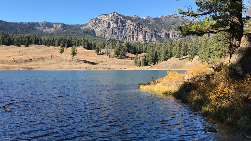
12. Trout Lake
Area of the Park: Lamar Valley
Distance: 1.2 Miles
Elevation Gain: 200 Feet
Difficulty: Easy
Accessible: No

Just south of the Pebble Creek Campground, you’ll find an amazing little trail with stunning views. Surrounded by mountains, Trout Lake’s unique perspective makes it one of the best short hikes in Yellowstone.
From the parking lot, you’ll climb a steady, mildly strenuous trail through Douglas fir to the top of a ridge. From here you’ll descend to the lake shore.
It is likely that you will experience wildlife on this trail. Bison, otter, and the potential for bear sightings are high.
13. Upper Geyser Basin
Area of the Park: Old Faithful
Distance: 4.9 Miles
Elevation Gain: 357 Feet
Difficulty: Easy to Moderate
Accessible: Portions are, yes!

Most famous for Old Faithful, this Geyser Basin has the largest concentration of Geysers in the world. There are hundreds of accessible geysers and hot springs in the Upper Geyser Basin. Luckily, park rangers predict the times for Castle, Daisy, Grand, Riverside, and Old Faithful so you can plan your excursion around that knowledge.
You can choose how long or short you want your hike to be. These boardwalk hikes intersect and branch off creating multiple routes. If you have the ability, take the hike up the observation point trail and check out Solitary geyser to escape the crowds.
It’s important to note that although you can’t ride your bike on the boardwalk, you can ride your bike on multiple paths around the Old Faithful area (all the way down to Biscuit Basin). We highly recommend stopping into the Old Faithful Visitor Education center to learn more about Upper Geyser Basin. Additionally, check out the lodges for some impressive architecture and a hot meal!
14. West Thumb
Area of the Park: Yellowstone Lake
Distance: 1 Mile
Elevation Gain: 59 Feet
Difficulty: Easy
Accessible: Yes

West Thumb is definitely the most scenic of all the hydrothermal areas. Set alongside Yellowstone Lake, the views are simply unmatched.
A boardwalk-style trail brings you through a variety of hot springs, including the beautifully blue Abyss Pool (one of my personal favorites on the trip!) and Black Pool. You’ll also pass by Fishing Cone, a hot spring located in the lake that has also acted as a Geyser in the past.
It’s all very interesting and so incredibly beautiful. Definitely one of my favorite Geyser Basins in the park due to its unmatched beauty and shockingly low crowds.
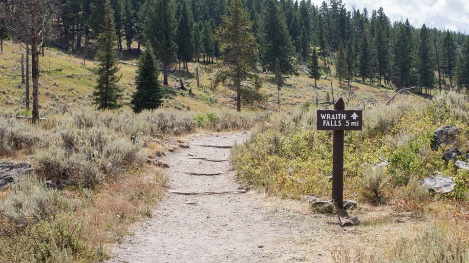
15. Wraith Falls
Area of the Park: Mammoth Hot Springs
Distance: .9 Miles
Elevation Gain: 65 Feet
Difficulty: Easy
Accessible: No

National Park Service
A short, easy hike that brings you through a meadow of sagebrush and conifer forest to the base of a 79-foot waterfall. In the Spring and early summer, Wraith Falls takes up the entire rock face with flowing water. In the dry season, you can expect the water to split in the middle and flow down the sides.
The parking area is located between Roosevelt and Mammoth Hot Springs. A simple, scenic trail will bring you to a cascading waterfall. From the lot, a short walk will bring you to an easy climb with a fenced-in viewpoint 200 feet from Wraith Falls.
Visit this waterfall in late Spring and early Summer when the snow melt has it flowing at its fiercest. You may also see Marmot, Elk, and other small rodents on the trail.

Best Long Hikes in Yellowstone
If your skill level allows, here is a list of long and/or more difficult hikes in Yellowstone National Park that are absolutely worth it. A lot of these are popular trails, they just tend to be on the more difficult side so less people attempt them. This will provide you with more peace, quiet, and solitude than the shorter trails.
Here’s the 5 Best Hikes in Yellowstone for getting off the beaten path!
1. Avalanche Peak
Area of the Park: Yellowstone Lake
Distance: 4.7 Miles
Elevation Gain: 2,100 Feet
Difficulty: Strenuous

Avalanche Peak is one of the best hikes in Yellowstone. On a clear day, you can see Grant Teton National Park’s mountains from its 10,568-foot summit.
This hike is rated as strenuous as it is a short, but steep climb to the summit. You will gain 2,100 feet in a mere 2.3 miles. We suggest you start your hike early in the day. It’ll provide you ample time to complete your hike and return back to treeline before afternoon thunderstorms.
Even in early July, this trail can be covered in snow and ice at its higher elevation. Check trail conditions with a ranger if you plan on hiking Avalanche Peak early in the season. Additionally, this trail can also be closed for bear activity. Grizzly Bears frequent this area in the fall months so be sure to respect trail status.
2. Bunsen Peak
Area of the Park: Mammoth Hot Springs
Distance: 4.6 Miles
Elevation Gain: 1,300 Feet
Difficulty: Moderate

Bunsen Peak is quite the beauty! The summit provides panoramic views of the Blacktail Deer Plateau, Gallatin Mountain Range, and the Yellowstone River Valley.
This moderate hike starts off with a mellow, but immediate climb as you meander through forested areas. At about one mile in you’ll begin switchbacking up the mountain. There are a few steep sections throughout the hike, but there are no steep drop-offs or exposure.
The parking area for this hike is quite small, we suggest arriving in the early morning hours. It’s also important to note that grizzly bears frequent this area. Carry bear spray, hike in groups, and make noise while hiking the Bunsen Peak trail.
3. Fairy Falls
Area of the Park: Old Faithful
Distance: 4.8
Elevation Gain: 170 Feet
Difficulty: Easy – Moderate

At 200 feet high, Fairy Falls is one of Yellowstone’s most spectacular waterfalls. It’s the park’s tallest front-country waterfall and absolutely worth the trip.
You can complete this hike from one of two trailheads. The first, and most popular trail, begins at Grand Prismatic Overlook. Kill two birds with one stone by hitting the overlook viewpoint and hiking to Fairy Falls via the same trailhead. At the turnoff point, you’ll continue an additional 1.6 miles through a lodgepole forest to the falls.
The second, and significantly less popular, includes parking at the end of Fountain Flat Drive. We opted for this trailhead because we rode our bikes the one mile to Fairy Falls turn off where ditched two wheels for two feet to see the falls. There is a bike rack available for you to chain your bike up!
4. Mount Washburn
Area of the Park: Between Grand Canyon of the Yellowstone & Lamar Valley
Distance: 6.8
Elevation Gain: 1,394 Feet
Difficulty: Moderate – Strenuous

National Park Service
A steady incline will bring you stunning 360-degree views of Yellowstone National Park. This iconic hike offers breathtaking views from its summit that you will simply never forget.
Located between Canyon Village and Tower Fall, the Dunraven Pass parking lot does fill up as this is an incredibly popular hike. The trail is wide and gradually ascends Mount Washburn. It’s important that you stay on the trail so as to not damage the fragile alpine vegetation that surrounds the trail.
If you’d prefer to bike this trail, park at the Chittenden Road access lot. Gain 1,500 feet in 2.5 miles of dirt and gravel on an old service road (and the highest road in the park!).
5. Specimen Ridge
Area of the Park: Lamar Valley
Distance: 16.9 Miles
Elevation Gain: 3,861 Feet
Difficulty: Strenuous

Go for a hike on the path less traveled and experience some of Yellowstone’s most iconic terrain. With sweeping views into the wildlife-filled Lamar Valley, there really isn’t anything quite like this hike anywhere else.
If you’re looking to complete the whole hike, it’s a point-to-point and will require a self-planned shuttle. You can complete this hike as an out and back by selecting a point along the trail to turn around at. Amethyst Mountain makes for a pretty solid turnaround point.
You are likely to encounter wildlife on this hike including, but not limited to, Big Horn Sheep, Marmot, and Bison. You will definitely experience more wildlife than people so be prepared for the rugged terrain that Yellowstone’s backcountry has to offer.


WanderwithKT’s
Yellowstone Gear Recs.
These are affiliate links. They help me out at no further cost to you!
Map
Bear Spray
Sun Shirt
Annual Park Pass
10 Must-Have Items for Hiking Yellowstone
Here are the 10 (plus a bonus) must-have items you should be wearing/carrying when hiking Yellowstone. Linked are my favorite versions of each recommended item!
- Hiking Boots or Sneakers
- Yellowstone Trail Map
- Bear Spray
- Sun Protection
- Bucket Hat, Long Sleeves, Sunscreen, Sun Glasses, etc.
- Headlamp
- Bear Bell
- Comfortable Backpack
- Binoculars
- Warm Clothing Layers
- Down Jacket, Vest, Beanie
- Rain Gear
- First Aid Kit (Bonus)
Check out our full packing list for Yellowstone adventures!
These links are affiliate links which provides me with a small bit of compensation at no extra cost to you.
Conclusion
America’s first National Park includes miles of trails for all ability levels. From boardwalk trail to rugged mountain ranges, it’s a great place to explore at any stage in life.
Hiking isn’t all Yellowstone has to offer. There’s always a good chance you’ll experience wildlife, such as black bears, elk, and big horn sheep during your stay. Yellowstone is one of the best places to view wild wolves and grizzly bears in the United States of America.
Plan a 5-day Yellowstone adventure and include all of the best short hikes in Yellowstone to make sure you see it all.